Located- Located in the continent of the Caribbean, Bahamas covers 10,010 square kilometers of land and 3,870 square kilometers of water, making it the 162nd largest nation in the world with a total area of 13,880 square kilometers.
Travel- By plane
Climate-Warmed and cooled by the trade winds, the weather in The Bahamas Out Islands is always perfect for tropical vacation getaway. Temperatures in most of the Out Islands of The Bahamas linger between 70 and 80 degrees Fahrenheit, thanks to the constant gentle trade winds.
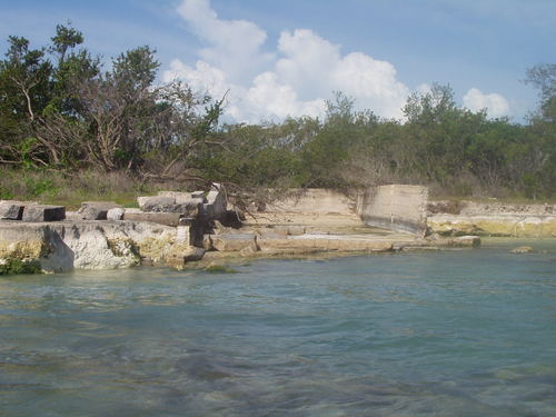
Landforms- Bahamas Geography. The Bahamas (all coral in origin) are a group of nearly 700 (atolls) ringlike coral islands, and (cays) small, low islands composed largely of coral or sand. The islands were mostly created by the disintegration of coral reefs and seashells, and low scrub covers much of their surfaces.
Money- Bahamian dollar
Population- 392,718

Lakes

|
Lake Rosa- Lake Rosa, also known as Lake Windsor, is the largest lake in The Islands of The Bahamas, stretching 12 miles (19 km) and occupying nearly one-quarter of the interior of Great Inagua. It is home to the largest flock of flamingos in the Western Hemisphere, plus many other kinds of sea and shore birds, including roseate spoonbills, herons, egrets, pelicans, and ducks. There you can also see the 60 Salt Reservoirs where salt is naturally made from sea water, sunshine, and breeze. |
|
Fresh Lake- More than three dozen prehistoric sites exist on San Salvador Island, Bahamas. These consist of small settlements and work areas of the indigenous Lucayans. One of these sites, the Fresh Lake site (SS-7), has been the focus of research by Youngstown State University archaeologists each December since 2012. No clear signs of habitation have yet been found, although over 100 shell beads, along with pottery, shell tools, and shells and fish bones, have been recovered. |

|
Lake Cunningham- Lake Cunningham is an artificial lake in Lake Cunningham Park, in East San Jose, California, near the Eastridge Mall and Eastridge Transit Center. It is not a geological feature recognized in the Geographic Names Information System (GNIS). It is located on Capitol Expressway and stands next to Reid-Hillview Airport. The Lake Cunningham Skate Park and Raging Waters theme park are also in Lake Cunningham Park. Laguna Secayre covered a much larger area than Lake Cunningham Park does now.[1] |
Rivers

|
Hawk Creek- Hawk Creek is situated in Fresh Creek District, Bahamas. Original name (with diacritics) of the place is Hawk Creek. Geonames-ID: 3572223. Hawk Creek maps, photos and images from google. Read wikipedia articles about and around Hawk Creek. Other places near Hawk Creek. More information about Hawk Creek. This placemark was added 1993-12-30. |

|
Deep Creek- Deep Creek gets its name from a deep creek that faces the settlement. The creek, which is quite shallow, empties out at low tide and fills back up at high tide, bringing the bonefish in with it. The settlement is divided into four parts: Delancey Town, Free Town, Sweeting's Town, and Thompson's Town. There is no harbour here, but almost everyone is able to paddle out to their boats to go fishing. For sports fishing and great snorkeling, you can visit Schooner Cay and the sandbars, or dive, fish, and conch with a tour company located in town. |

|
Goose River- Goose River is situated in Fresh Creek District, Bahamas. Original name (with diacritics) of the place is Goose River. Geonames-ID: 3572321. Goose River maps, photos and images from google. Read wikipedia articles about and around Goose River. Other places near Goose River. More information about Goose River. This placemark was added 2010-08-10. |
Mountains

|
Mount Alvernia- Mount Alvernia is located on Cat Island in the Bahamas and is the highest point in the country at 63 metres above sea level. The Mountain shares its name with a school in Montego Bay, Jamaica. Originally named "Como Hill", it was renamed Mount Alvernia after La Verna, the hill in Tuscany where St. Francis of Assisi received the Wounds of the Cross. The mountain was given its name by a Catholic priest, Monsignor John Hawes, also known as Fra Jerome, who built a hermitage there. |
|
St. Lucia- The nearest volcano is in St. Lucia which is approximately 2,155 km from the Bahamas to St. Lucia. Soufriere Volcano in St. Lucia is considered to be dormant and it last rerupted was in the 18th century. Tourists were allowed to walk on these thin layers but an incident happened, so they are only allowed to stay behind the fence. The French were the island's first European settlers. They signed a treaty with the native Carib Indians in 1660. England took control of the island from 1663 to 1667. In ensuing years, it was at war with France 14 times, and rule of the island changed frequently (it was seven times each ruled by the French and British). |
Caves

|
Blue Holes- A blue hole is a large marine cavern or sinkhole, which is open to the surface and has developed in a bank or island composed of a carbonate bedrock (limestone or coral reef). Blue holes typically contain tidally-influenced water of fresh, marine, or mixed chemistry. They extend below sea level for most of their depth and may provide access to submerged cave passages. Well-known examples can be found in South China Sea (Dragon Hole), Belize, the Bahamas, Guam, Australia (in the Great Barrier Reef), and Egypt (in the Red Sea). Blue holes are distinguished from cenotes in that the latter are inland voids usually containing fresh groundwater rather than seawater. |

|
Ben's Cave- Ben's Cave is one of the two inland blue holes within The Lucayan National Park.This natural feature is definitely a sight to see and a dive into the cavern is a visit into the ancient past. The clear upper portion of the water within the cave is fresh. It floats on top of the lower salt water. The passages withing this cavern system extend horizontally for thousands of yards and it is deemed to be one of the longest surveyed cavern systems in the world. You must be accompanied by an authorized dive instructor in order to dive here, which will be arranged prior to the dive date. During the dive, a showcase of interesting features will be on display such as stalactites, stalagmites, a halocline, fossilized conch shells, bivalves and much more. |
Weather

|
The Bahamas climate is semi tropical with two seasons. Summer and winter, with summer also serving as the rainy season. During the summer, which is from May to September, Bahamas climate is warm and humid with temperatures ranging from 21C to 34C. Rain falls between the months of May to October and the hurricane season extends from June to November. Although the Bahamas is in the hurricane belt the government has equipped itself with weather devices that tracks hurricanes from the time they form and monitors its movement, giving the visitors more time to prepare if ever a hurricane will hit the island. Winter in the Bahamas is from October through April. Temperature during this season ranges from 24C to 29C with lower temperatures from January to February. Perfect for a walk on the beach with a slightly cooler breeze embracing you. The Bahamas climate all in all is generally warm which makes it a perfect vacation destination all year round. The ocean is usually calm and warm that makes it perfect for swimming, snorkeling and other water sports. |
Natural Resources
The natural resources of the Bahamas include salt, aragonite, timber and arable land. Aragonite is one of two naturally occurring crystalline forms of calcium carbonate and is present due to the coral on the islands. Major industries include cement-making, oil refining and trans-shipment, salt production, rum distilling, aragonite, pharmaceuticals, and spiral-welded steel pipe manufacture. Freeport, on the island of Grand Bahama, is The Bahamas' largest industrial and manufacturing centre. Natural resources: coal, copper, lead, molybdenum, phosphates, rare earth elements, uranium, bauxite, gold, iron, mercury, nickel, potash, silver, tungsten, zinc, petroleum, natural gas, timber.The system of general education that exists now throughout the Bahamas may afford a salutary check to the evil influences of wrecking, and may turn the minds of the rising generation to the contemplation of a wiser and more wholesome avocation.
note: the US has the world's largest coal reserves with 491 billion short tons accounting for 27% of the world's total.Bahamians who are really interested in the future prosperity of their Islands would do well to prepare the way for the abolition of the present system of wrecking. Its evil influences are becoming more marked and more widely extended every day, and if it be not crushed, it will eat up all the life and industry of the Colony.
Seasons
There's a much greater chance of rain during the summer and fall. The curse of Bahamian weather, the hurricane season, lasts (officially) from June 1 to November 30. But there is no cause for panic. More tropical cyclones pound the U.S. mainland than The Bahamas. The temperature in The Bahamas averages between 75°F and 84°F (24°C-29°C) in both winter and summer, although it can get chilly in the early morning and at night. The temperature in The Bahamas averages between 75°F and 84°F (24°C-29°C) in both winter and summer, although it can get chilly in the early morning and at night. There's a much greater chance of rain during the summer and fall. The curse of Bahamian weather, the hurricane season, lasts (officially) from June 1 to November 30. But there is no cause for panic. More tropical cyclones pound the U.S. mainland than The Bahamas. Throughout March and into mid-April, it's spring-break season in the Caribbean for vacationing college and high-school students. Expect beach parties, sports events, and musical entertainment; if the idea of hundreds of partying fraternity kids doesn't appeal to you, beware. The Bahamas is a year-round destination. The islands' "off season" runs from late spring to late fall, when tolerable temperatures prevail throughout most of the region. Trade winds ensure comfortable days and nights, even in accommodations without air-conditioning.The Bahamas is a year-round destination.

